As Seen From Space: How Satellites, Software, and Open Science Can Scan – and Help Save – Earth's Ecosystems
A research team used CyVerse and Google Earth Engine to study Earth's dynamic ecosystems over time. Their results are published as a "research object" – a cutting-edge example of Open Science.
Thanks to a novel integration of technologies, scientists can now use a suite of publicly available research data and tools to see how global ecosystems change across time.
"It's not just a result, it's a whole new method of seeing the world," said Don Falk, a professor in the University of Arizona's School of Natural Resources in the College of Agriculture and Life Sciences, and a contributing author.
The research team has assembled its technique in a manuscript published in the Multidisciplinary Digital Publishing Institute (MDPI) journal Remote Sensing.
Tyson Swetnam.
The publication represents the first use of CyVerse's Visual and Interactive Computing Environment (VICE) to build a "research object" – a completely reproducible package of the team's data, code, software packages, and manuscript.
"We're giving the reader everything they need to reproduce our workflow," said Tyson Swetnam, a CyVerse science analyst and the study's lead author, describing the team's Open Science methodology, in which research methods and findings are freely accessible by all who may wish to read or reproduce a study.
The beauty of these tools, noted Falk, is that they offer the ability to integrate information from multiple sources to investigate all kinds of questions.
"This approach enables researchers to ask the questions of our time," he said. "How is the earth system responding to massive change in the climate system? How are the ecosystems in turn influencing climate?"
With satellites and software
To demonstrate the power of their technique, Swetnam and his colleagues selected four ecological sites on four continents, each representing a dynamic environment susceptible to climatic and human impact.
They used data available through Google Earth Engine, a cyberinfrastructure
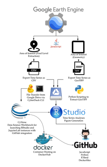
The team processed their data through several open source technologies to yield their final results.
providing researchers with access to the vast archive of public satellite imagery and geospatial datasets of the Earth.
"With Earth Engine, we're able to very quickly extract the whole history of satellite remote sensing," said Swetnam. "There are hundreds of datasets now, and Earth Engine can generate animations that span every date."
The team exported their datasets, amounting to roughly 25 gigabytes, to CyVerse's Data Store, where they could further apply CyVerse's VICE processing power to run the suite of statistical tools available through R Studio.
The results of their analyses are high-resolution over time and space, giving information about how the land surface is continually changing.
"We've never had the ability to look at climate impacts on ecosystems in so many different ways in so many parts of the world, so easily," said Falk.
"As satellites get better, we get better spatial, temporal, and spectral precisions – we can discern soil moisture and leaf green-up more accurately, he explained. "Before, we might not see a change in a forest until was nearly dead. Now, we can see the leading edge, catch the changes as they're happening."
And because the information is freely available, these tools can now serve as a diagnostic for land managers to determine what areas are suffering most and apply appropriate intervention strategies.
Funded by the National Science Foundation, CyVerse provides free access for researchers to its suite of software tools and workflows, computational power, and data storage. CyVerse also offers training in Open Science methodologies and the use of its platform through the CyVerse Learning Center.
The new ecology
"We picked four places on four different continents as representative ecosystems of how you can look for disturbance and weather climate impacts over time," said Swetnam.
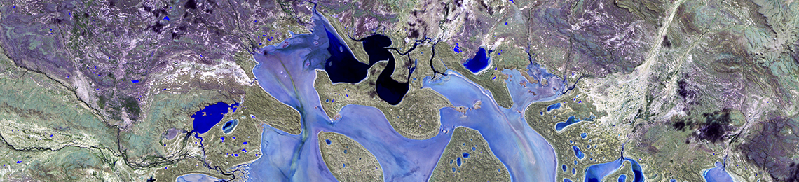
The Okavango Delta in Africa is green in the river delta, but fades to savanna in the surrounding uplands.
"The Acre Rainforest in Brazil is always green, but you can see how the rainforest becomes less green as it's undergoing drought and deforestation," Swetnam continued.
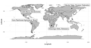
The team selected four sites with varying vegetation types, land use practices, and climatic conditions.
"At our site in Siberia, a conifer forest with sedge and lichen meadows, you can see forest fires and drought conditions scarring the meadows and the forest over time."
And finally, the border wall between the United States and Mexico creates a natural experiment, Swetnam said. The soil and climate conditions are identical on either side of the fence, so any changes in the ecology are a result of differences in land use, such as heavier cattle grazing to the north.
The team created an index of the average conditions for their study sites for every day of the year, encompassing the entire era of satellite remote sensing – about 36 years.
"As we look at the data, each site reveals its own unique disturbances," said Swetnam. "And you can do this for any ecosystem."
For Falk, he hopes other scientists will take the opportunity of these novel technologies to study climate impact across the globe.
"Ecosystems are a large part of the solution to climate change, because they are a huge reservoir of carbon. Some of the most important work that could come from these results are that researchers could look at this question of whether global ecosystems will continue to be able to keep carbon out of the atmosphere."
"This isn't just a research finding," Falk reiterated. "It's a new tool for looking anywhere on the globe."
Other contributing authors include Emeritus Professor Stephen Yool of UArizona's School of Geography and Development in the College of Social and Behavioral Sciences, and Samapriya Roy, a customer and researcher engagement and senior solutions engineer at Planet Labs. Roy began interacting with CyVerse through Lemon Labs, an innovation workshop hosted by UArizona. Said Roy: "I enjoy working on interesting problems, and avenues like Lemon Labs and my relationship with CyVerse overall help build that foundation, providing collaborations that can last a lifetime."