From Landforms to Landslides, Students Investigate Earth Surface Processes with CyVerse
A professor created activities in CyVerse to teach undergraduate geology majors the foundational concepts of both geosciences and computational sciences.
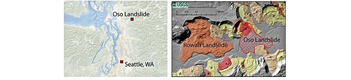
The map at left shows the location of the 2014 Oso Landslide relative to Seattle, WA. The aerial image (right) shows the extent of the landslide event. Image courtesy of Luke McGuire/UArizona.
For today's undergraduate students of natural sciences, a solid understanding of computational data science is essential – for both their classwork, and their future careers.
Understanding that, Luke McGuire, an Assistant Professor of Geosciences at the University of Arizona, gave his spring 2021 students an introduction to both foundational concepts of geosciences and computational sciences in his class, Geosciences 300: Earth Surface Processes.
The course introduces geosciences majors to the processes that create and modify landforms, such as erosion, debris flows, and landslides. While most geology courses focus on processes in the planet's interior core or mantle, GEOS 300 focuses on surface processes – "which I would argue is more important, because we need to understand what's happening around us and how we can protect our infrastructure," said geosciences major Ben McNabnay, who took the class this past semester.
Luke McGuire
McGuire taught his students to work with numerical models to quantify these processes in Project Jupyter notebooks, an open document format that allows users to combine text and images with code, making it easy for those with little or no coding experience to work with models and change variables.
"Computation is very important in understanding surface processes," noted McNabnay, who is minoring in computer science. "A majority of this class was learning the equations and variables that we can use to understand what's happening on the planet around us."
McGuire had his students create a free CyVerse account, from which they could open a Jupyter notebook and analyze the data he gave them.
"Doing this in CyVerse ensured that the students had the computational resources they needed, regardless of what operating systems or setup they had at home," McGuire said. "With a CyVerse account, they had an environment ready to go, and I knew I could run the models that I wanted them to use."
"One of our primary goals at CyVerse is to provide resources for instructors to help students work with real data at scale," said Tyson Swetnam, a CyVerse science informatician who helped McGuire configure the CyVerse computational environment for the course.
Using CyVerse made it easy for students to pull data from McGuire's GitHub repository, streamlining the class activities and introducing the students to GitHub at the same time.
"It's also an opportunity for them to learn about cyberinfrastructure and collaborative research environments," McGuire added.
"The multimedia approach by Dr. McGuire was very helpful," McNabnay said. "I'm certain I'll be using these skills later in my career."
For Jill Cohen, a clinical pathologist who is studying geosciences as a second major for personal interest, the course provided a first look into computational sciences.
"I don't have a programming background," she said, "and I found this step-by-step process really easy to use to analyze data. It made modeling very approachable."
"I liked how you could change the variables in Jupyter notebooks and see how different processes or materials affected the landscapes, from actual landslides in Washington to stream channels cutting through rocks in the Catalina Mountains in Arizona."
McGuire set up five different assignment topics in Jupyter to guide his students through a series of modeling exercises using real-world data from actual geologic events, such as glacial deposits or landslides.
One exercise looked at the 2014 Oso Landslide in Washington state that devastated a community, destroying homes and leaving 43 dead. Working their way through the computer-based activities, the students used a numerical model to estimate the age of landslide deposits based on the roughness of the surface from aerial images, and then to assess risk of future events.
Another project asked students to use Google Earth to take measurements of glacial landforms. "I thought that was amazing because we used actual measurable data from the planet," McNabnay said.
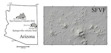
The San Francisco Volcanic Field in northern Arizona. Image courtesy of Luke McGuire.
Dr. Cohen's favorite project involved examining how the San Francisco volcanic field near Flagstaff, Arizona evolved over time, calculating the ages of unknown cinder cones based upon known ages of volcanic craters in the area. "The assignments made the material come alive," she said.
McGuire remarked that this was his intention. "This course was a way of allowing the students to explore the practical nature of the work that surface scientists do, and how it can be applied to solve real-world problems."
Information on CyVerse training and teaching resources is available at www.cyverse.org/learning. Email info@cyverse.org if you're interested in using CyVerse to teach a class.